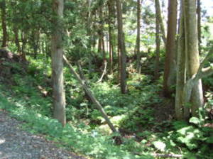
Shobusawa-toge pass was impassable by landslide in the Aizu big earthquake of Keicho 16 year(1611 year), and dug the
Kanetsukido-toge pass opened the road from Higashihaga to beyond the Kanetsukido-toge
pass to Ketanomiya. Opened the road
of Ketanomiya – Todera – Bange – Saikuna – Takaku and for Wakamatsu castle town, since then it will be the main road
of
Echigo-Kaido road.
Aizu-Bange town
has been damaged by fires, floods and earthquakes since from ancient times.
The town's appearance changed every time, and the route of "Echigo-Kaido road" of the town has also changed. Also most of the
old road has disappeared in the public works such as the Three-way road
digging in the Meiji period, the modern farmland
maintenance, the road maintenance, and the river construction, etc. In
now, it is only to fasten the historic sites and the remnant
in some places in the town. The person who knows it in detail and the
person who can recognize it is less in now.
This is also a chance to start up this HP.
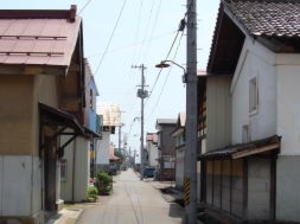
The photo is reminiscent of the old Kaido, on the old Echigo-Kaido road in the North-back-street behind the Hachini brewing.
The storehouse of the front left is the one that relocated the Rice-warehouse
of the Aizu clan. The Echigo-Kaido road before the
"North-back-street" was developed, entering Bange through Niidate
from Todera. It was route extending from the back of Jyorin-ji
temple to the east, from north stide behind Huruyashiki district, to the back of Hokkai-ji temple. Go further east and at the end of
street "Akebono brewery", go to south, and west back of Arai
clinic to go east, was out in the Habayashi village through the south
of Tenrikyo-Shin-Kawanuma-Bunkyokai. Now with the maintenance of Takada-Kaido
road, from the back of Arai clinic to
Tenrikyo-Shin-Kawanuma-Bunkyokai, between the Habayashi village has changed. "Habayashi" and between the
"Fukuhara"
on the other side across the Tsurunuma-river, was a port of ferryboat called "Saimyo-ji ferry" pass by boat. It seems that "Dobashi
(earth-paved bridge)" was hung in a dry season in winter. Because of the farmland consolidation and the river construction, all
the
remnants have disappeared, and ther is to guess the location.
There is a "pine of boat connect" in the north of the Habayashi
village, it is said that the boat was connected, but there is not a
vestige of old. "Saimyo-ji ferry" is, Bun-o 1st year (1260 year), it was named to commemorate visited Aizu of the 5th regent Hojo
Tokiyori of Kamakura shogunate.
Tokiyori is, it was called "Mr. Saimyo-ji" because it became
a priest in Saimyo-ji temple (another
name Soshu Zenko-ji temple) of Sagami country Matsuda (Oi-Matsuda town,
Ashigara county, Kanagawa prefecture).
From Fukuhara, through the "Saikuna", go out to "Tsukahara",
and cross the Aga-river (O-kawa) in "Takaku ferry", and in the
vicinity "Aizu Matsukawa-ya shop" on the opposite shore "Takaku",
and head to Wakamatsu castle town.
The old road has disappeared in the farmland maintenance between "Fukuhara"–"Tsukahara",
and it is extent that a part of the
road in the village can glimpse remnants of the Kaido road.
See the transition of the old Echigo-Kaido road in Aizu-Bange town Wellcome
material. The ancient time of Bange was dotted
with settlements in Ko-bange district and Furumachi-kawajiri district,
and was the route that leads to Niidate. The first period
of Suwa shrine was located in Furumachi-kawashiri district. Because Furumachi-kawashiri district was a riverbed of
Tsurunuma-river, it is said that it has repeatedly to relocated toward the current town by on each occasion the flood and the fire.
(Welcome map, Aizu Bange town Central
area map)
the history of Buddhism in Japan will be greatly rewritten.Military fire of Hoki 6 year is, the Yamato government which wants to
strengthen the Ritsuryo system in one theory, directed to Aizu Gunga (county
government offices). It is said that the seduces of
Tennei-ji temple (Higashiyama district, Aizu-Wakamatsu city) was made
to attack. And, the road which connects the Takadera
district in the mountain beyond from the Jingamine-jo castle is called
"Shobuzawa-toge pass".
At that time in
here, it is reported that there was a fierce battle between the Takadera temple
army and the Tenneij-i temple army.
The introduction of Buddhism in Japan history, it is said that it will
begin with the contributed to the Buddhist statues and the
Buddhist scriptures from Kudara (Baekje, one country of old Korea peninsula)
in the 538 year. Around the Tohoku region of the 6th
century, Ezo lives on was "the country of the peoples who live disobedient". It is good to be proud of the people who live in Aizu
-Bange town that the Buddhist kingdom of the Chinese direct biography
existed though it was a local state in the frontier ground
Aizu. As for this, was also the most annoying place for the Yamato administration, which aims to become centralization.
Why did Seigan come to Aizu-Bange at the risk of life, in the age when
the transportation method was not developed?
This is thinking from considering the history of China, the China Liang
country (Ryo, one country of old China) are founded in 502
year by the founder High ancester Butei of Liang (reigon 502 ~ 549 year). In China’s Northern and Southern Dynasties period, it
was a country that dominates the vast territory of today, Central China,
South China, Tibet, and part of Viet Nam. The scriptures
and Buddhist statues will be presented to the Japan at the time of Butei
of Liang(Ryo), and it will be a Buddhist introduction of
Japan history. He tried to build a cultural state based on the Buddhist spirit, but finances collapsed with excessive Buddhist
protection policies, and the Emperor was fall from power because of the
bureaucrats rebellion. The trust of the Butei was thick, and
the Seigan avoided this confusion, with the hope of a culture-state construction
ideal for the Butei, the hope of the construction of a
cultural nation with the ideals of Butei is in his heart. Relying on the wealthy tribe of Aizu-Bange there was an exchange with the continent at that time through the Kudara (Baekje) of the Korean peninsula, I think that it went north of the Sea of Japan by the
sea route. Why did the landed in Kyushu and not gone to the Yamato administration's
Kinai(now Kyoto,Nara,Osaka,Hyogo
prefecture) region? It is a power conflict that turns the throne in the
imperial court after the rebellion of Iwai in Kyushu at 529 year,
Because hated the religious war between Mr. Mononobe and Mr. Soga, I think that it aimed for Aizu-Bange. It was under the
influence of the Yamato government until in the now Onuma-county, it might
have been known that the Aizu-Bange area at that
time was one independent country by the wealthy tribe of Unai and Aozu
Kofun group typified by Kamegamori-kofun.
In the
column of "Teacup Mound Jizo", Kobo-Daishi Kukai was, looking for Koyasan as main temple for practice and propagation of the
doctrine in Japan on pilgrimage the whole country, put an episode that
says that I was entered in Aizu on the way.
Why didn’t Mt.
Takadera not become Koyasan, the reason is...,
Mt. Takadera which failed to become Koyasan, in Aizu-Bange
Storyteller version.
Once upon a time,
where the best place for Koyasan, it is said that it was looking all over the
country.
To the Koyasan, it had to be place there was the other peaks and 49 valleys.
Mr. Daishi was climbed to Mt. Takadera, though there
were 48 valleys when counting the valleys, there was not enough one count, it was that one missing if counted several times.
It seems that Mr. Daishi gave up, and opened Koyasan in Kishu (Wakayama
prefecture). To tell the truth, the valley was a 49, but it
was said the Perverse-person hiding one and it had to embarrassed Daishi.
It is said that the Mt. Takadera was not able to become
Koyasan because of such a reason. Children should not embarrass people like the Perverse-person. You will
be scolded by the Mr.
Daishi. It was told my grandmother often when I was young child.
And the Golden legend of the mystery of Mt. Takadera. This legend is the one that has been told in the Aizu-Bange region for a long
time, and there was a case to support it in the Meiji period. But it has
not yet been elucidated.
One day in the Meiji period, a farmer's horse ran away and went into Mt.
Takadera. The farmer went into the mountain and looked
for a horse all day, but it was not found at last. He gave up and went home, but the next day his horse came back with feet full of
blood. He was hurt and poor thing and he washed his blood with the wells, but he couldn't find any scars. If? When he take what
seems to be the remaining blood on his finger, it said that it was Vermilion,
not blood. The horse was in the mountain, and it might
have put into the foot in the jar of Vermilion and he went into the mountains and looked everywhere, but couldn't find it. In ancient
times, it was so precious and expensive that Vermilion was comparable
to gold and silver. The mystery of poetry, stand at before, sit
at behind, of Yamabuki (Japanese rose), Golden thousand barrels, Shu (Vermilion)
thousand barrels, is under the three leaves
Utsugi (Japanese bladdernut). And, buried and hidden the treasures in ground, it is said that the tree of three leaves Utsugi was
made a mark. Many peoples have challenged this mystery before, but the
tree of the two leaves Utsugi is easily found, but because
the tree of the three leaves Utsugi is not found at all, this solve the
mystery is made more difficult.
(Welcome map, Aizu Bange town North-West area map)
time of Aizu the 3rd Lord Mr. Matsudaira Masakata. It became the surname
Matsudaira from the Hoshina surname from the
time of the official, and licensed the use of Aoi crest. At the time of Mr. Hoshina Masayuki, the use of Matsudaira surname and
Aoi crest was advised from the Tokugawa family, but Mr. Masayuki "too much for me." in declined it. The Tokugawa shogun
is three leaves Aoi with 37-leaf vein in a circle, and Aizu Matsudaira is called Aizu Aoi with 57-leaf vein of three leaf Aoi in a
circle. Fukushima prefectural Aoi High School(old Aizu Women's High School)
is although Aoi crest has been used in the
school emblem, this is a crest called Tachi-Aoi(Hollyhock).
In addition, Kyoho years, nationwide and Aizu was hit by a famine typhoons,
floods and famine. The Bange 341 houses were
burnt down by the big fire, and the Suwa shrine was also burnt. From this
time on, the financial situation of the Aizu domain
and other domains will begin to deteriorate.
Mr. Hoshina Masayuki
is brother by defferent mothers of the Tokugawa 3rd Shogun Tokugawa Iemitsu.
Admission : Free
Closed on : January 1st ~ March 31st, Monday (if holidays
is next day)
Admission Time : 9:00 〜 16:00
(Welcome map, Aizu Bange town North-West
area map)
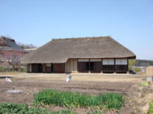
This house was originally used as a residence of the Igarashi family in the Naka-Kaizu district
of the Showa 30 year (1955 year). In the hipped roof style of the thatched,
at the time of disman
tling and relocated of Showa 43 year (1968 year), in the mortise of beams, Kyoho 14 year (1792
year, the time of Shogun Tokugawa Yoshimune) of written Sumi ink has been
found. It is design
ated as an important cultural property of the county in Showa 46 year (1971 year) as a typical
example as the dwelling of the farmer in Aizu at the time of construction. The inside is a folk
material exhibition hall, and it is possible to experience the living space at that time.
It has been confirmed that the construction of 280 years ago. Kyoho 14
year(1792 year) is, the
The tragic love of
Hatsune…
There is an inn(Yadoya or Hatago) called Nakamuraya in the Todera at old
times, and there was a maid of a beautiful woman
named Hatsune. One day a young handsome monk stayed to Nakamuraya on the
way of his pilgrimage. Hatsune fell in love with
this monk at first sight. She taking care of the things his around, she sometimes put on a motion, but the trained monk didn't
accept the love of Hatsune. The monk left for a pilgrimage the next morning
when he stayed overnight. Hatsune can't forget about
the monk, he dined with a teacup(chawan) he used, when she was thinking
in the morning and evening. Strangely, she become
pregnant and gave birth to a boy. On the other hand, the handsome monk visited the Todera again and stayed to Nakamuraya.
Hatsune delighted "your child is growing up with vigor." to
the monk. The monk said, "the child is not a true human because he
was born with your thoughts". To chanting sutra, the teacup of that
time is covered with the child's head, it is said that the
appearance of the child has disappeared with suddenly. After that, it is said that it filled the one that the teacup and sutra was
written on stone for a memorial service, and the Jizo was to enshrined
on it. It came to call it the Teacup Mound Jizo(Chawan-zu
ka-Jizo), and it is said that it is enshrined still as the old days as it is now. The young handsome monk at this time, he was walki
ng around the country looking for a good place to do Koyasan, has been told that it was a young day Kobo-Daishi Kukai.
(Welcome map, Aizu Bange town North-West
area map)
The original was about 3m east, moved to the current location at the time
of the Three-way-road-construction of Meiji 15 year (1882
year, the time of the Rokumeikan). The construction is Genroku years old about 300 years ago, and the make
out has been reported
ly the Aizu clan Mr. Kujiraoka Heiemon.
(Welcome map, Aizu Bange town North-West area map) (Welcome materials, to the old Echigo-Kaido transition diagram)
The Three-way-road-construction is, Meiji 15 year(1882 year, time of the
great Japan Imperial Constitution was drafted), the road
that was built by the plan of the prefectural governor (now referred to as governor of the prefecture) by Mishima Tsunemichi, from
Aizu-Wakamatsu and to Tokyo by the Aizu-Nishi(West)-Kaido road, to Yamagata
by the Yonezawa-Kaido road, and it is a three
Kaido road which connects to Niigata by the Echigo-Kaido road. Completed in Meiji 17 year(1884 year). But now it is a public enter
prise that says, Mishima forced the work of the construction to the roadside
inhabitants. Collecting heavy common benefits, in addi
tion the construction was built with tyranny, such as the forced expropriation
of road sites. At that time, it was the one that the supp
ression to the Liberal Democratic Movement which had shown the upsurge
in the Aizu region was put in view. Dissatisfaction with
this forcible road construction, it leads to the uproar of the Liberal
Democratic Movement, the after such as the Kitakata incident
immediately. This road is, it was a Military-road to counter the Imperial Russia was
aiming to advance to the Far East at the time,
when the Ban-Etsu-line(now, JR Ban-Etsu-west-line, from Iwaki city in
Fukushima prefecture to Niitsu city in Niigata prefecture) is
opened, it becomes the one only to be used as the local people's life
road as usual. My maternal grandfather was doing this story well
during his lifetime, to the state of the prefectural government of Mishima
Tsunemichi that served in the Boshin-War and the Satsu
ma clan, he was called "Tsuyo" with the anger and contempt without
calling the name "Tsunemichi". Mishima also conducts the
government of wholly-devoted crackdown in former post Yamagata prefecture
too.
but as soon as the princess became seriously ill, the villagers were reluctant to no one was able to come in gradually. However, the
villager of Kaeruda had mercy the princess, stood the cabin in the north
of village, and looked after. Because it was an old time
when medical treatment was not enough, she finally passed away. The villagers felt so sorry, "What a pity! ". And buried in the
place where lived until now, and carved a stone statue, and the statue
is named "Osawa Gongen" and it has made a memorial
service. What a heart-friendly of peoples were the Kaeruda ancestors.
It has been renamed "Osawa Shrine" since the Meiji period.
Considering these, I think that the founded of the shrine is around the
11th century.
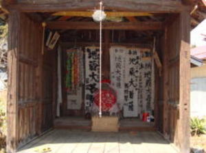
Jizo of the Jizo-do hall in front of the shrine is called "Oshiroi(powder)
Jizo". Originally, it was in the main building of Osawa shri
ne, but since it was a Jizo of the shape of priest, the present Jizo-do
hall was build and moved at the time of edict on the separati
on Shinto and Buddhism issued of the Meiji period. When have a boil on
the face of a child, the rice powder is painted on the face
of Jizo and praying, it is tradition said that the boil is cured when the
remaining powder is applied to the affected part of the child's
face.
It is said that this Jizo is a stone statue that is carved by the ancestors
of the Kaeruda, memory the daughter of Abe-no-
Sadato.
"Dosu"
of "Dosugasawa" is an old dialect of the Aizu region, meaning "Leprosy",
so I guess the Princess's disease was Leprosy.
O-sawa of Princess O-sawa becomes the Osawa, and it becomes Osawa Gongen to convert it to enshrines the Sukunahiko-no-mi
koto, and it said would have been renamed Osawa Shrine finally.Even now, the face
of O-Jizo-sama is white.
Is there any grace
to the acne of the youth? Hmm…! Who knows!
(Welcome map, Aizu Bange town North-West
area map)
In the Shinpen-Aizu-Fudoki, it is said that "East-West 1-Cho (164m), North-South 1-Cho 40-Ken(182m), Jo Shiro Nagamochi is
built and is one of the 28 fortified mansions. It is described as. This was at the time of the Hoan 1st Year (1120 year, the end of
Heian period), and Jo family was in his heyday. The Diary "Gyokuyo"
of Kujo Kanezane. There is a possibility of "Aitsu-no-shiro
(the castle of Aizu)" which comes out in "Heike Monogatari",
this is the most notable castle ruins in Fukushima prefecture.
The double dry moat in the south, west and north is 15m deep and there is a place width is with a range locations of 60m.
The east is a bold cliff of 20m in height, and at that time, the Tsurunuma-gawa river was flowing under this eria. In the battle
of the Heian period, which is mainly a bow and arrow, it is not necessary
to have such a huge castle, but it is presumed to
represent the power and authority of lord of a castle.
The Aizu Bange town board of ducation conducts excavation surveys three
times from Heisei 14 year (2002 year). It results, from
the castle ruins, the time of Song Dynasty(So, old China, the 12th century, the Heian period in Japan) was excavated by a jar of
white porcelain jar made in China and a bowls of Korean celadon, and in
addition, the first copper weight (balance weight) has
been excavated in East- Japan.
It can be said that there was an influential wealthy tribe comparable to
Oshu Fujiwara in Oshu
Hiraizumi (Hiraizumi town, Nishiiwai county, Iwate Prefecture). Jo shiro
Nagamochi is a powerful family of Echigo Mr Taira of
Echigo-Kambara-Gun (Kambara-gun, Niigata Prefecture) and aims to invade Aizu, it is said that it built the Aizu 28 castle
mansion aiming at the invasion to Aizu. The castle mansion group is placed
in a way that surrounds "Takadera Sanzen (3000)-Bo
(priest’s house)" and is one of the factors for the abolition of
"Takadera".
Jo shiro Nagamochi was Jyuei 1st year (1182 year, during the end of Heian
period), he went to the front to Shinano (Nagano
prefucture) with Echigo(Niigata prefecture), Dewa (Akita, Yamagata prefecture)
and 40,000 soldiers of Aizu 4 counties.
It fights
in Kiso Yoshinaka and Yokota-Kawara (Shinonoi, Nagano city, Nagano prefecture) which made
the soldier of raised up army the
anti-Heike, but crushing defeat. After the Oshu Mr. Fujiwara was taken over by the Jingamine-jo castle.
And to the decline of Mr. Jo. It is a
ruins reminiscent of all that remains of warriors dreams.
(Welcome map, Aizu Bange town North-west area map)
Unai Yakushi". National designated important cultural property. Image height 183cm, one wooden cypress, and it is the one which
works the same flow as a national treasure Yakushi statue of "Shojo-ji
temple" of Kawanuma-county Yugawa village, but unlike the
Shojo-ji Yakushi statue (Kongo- kai Yakushi) of severe features in training,
the Kami-Unai Yakushi has a calm expression after the
Enlightenment (Taizo-kai Yakushi). The work of about the 10th century.
In the history of Fukushima prefecture, it is said that a
Yakushi seated statue was built at Chogo-ji temple in Unai village, Kawanuma-county.
It is counted in one of "Aizu-Five-Yakushi"
opened by Tokuitsu Daishi. Eisho 15 year (1518 year), it was devastated by the damage of the Aizu
large flood, at the Koji 1st year
(1555 year) it was rebuilt. Converted to Soto-shu(sect) in the Shoho 2
year (1645 year).
The Keicho 16 year (1611 year), which was damaged by the Aizu large earthquake,
passed through this land the layman priest
monk Doan of Sagami country Odawara (Odawara city, Kanagawa prefecture)
discovered that the Yakushi statue was exposed to
the wind and rain. From Genroku 4 year (1691 year) to expend the private funds, and it was said that the temple was revived and
the Yakushi statue was enshrined. In Genroku 9 year (1695 year), the temple’s
constructed in celebration was done.
The principal image of the Yakushi statue is now store up in the cover
housing.
In the Yakushi-Do, the Zolkova wooden joined block construction of the
Muromachi period, Nikko Bosatsu statue (Sun light
Bodhisattva 173cm), Gakko Bosatsu statue (Moon light Bodhisattva 172cm),
Hoko-Koku-zo statue (Treasure Light statue), Sho-
Kannon statue (184 cm), and can see a variety of old Ema drawn from Genroku
to the Hoei years (1688 year ~ 1710 year).
(Ema is a prefecture designated important cultural property)
When see the Nikko and Gakko Bosatsu statues, Hoko-Koku-zo statue and the
Sho-Kannon statues, well can imagine that at the time
of the founding and heyday of the Chogo-ji temple, the Shiten-no (Four
Heavenly kings), the Juni-Shinsho (Twelfth God general) and
the other Kenzoku (disciples or followers) are assemble, and will imagine it was
magnificent Shumidan(dais for a Buddhist image).
Hakusan Shrine next to Yakushi-Do is enshrined, the hill of about 5m height is an not yet investigated kofun.
(Welcome map, Aizu Bange town North-west
area map)
Aizu 5-Yakushi is,
➀ Central Yakushi, Shojo-ji temple, Yugawa village Kawanuma-county.
➁ Eastern Yakushi, Enichi-ji temple, Bandai-machi(town) Yama-county.
➂ Western Yakushi, Kamiunai Yakushi, Aizu Bange twon, Kawanuma-couunty.
➃ Southern Yakushi, Nodera Yakushi, Monden-machi(town), Aizu-Wakamatsu city.
➄ Northern Yakushi, Kitayama Yakushi, Kita-Shiobara village, Yama-county.
Say these. The existence of the Yakushi-Buddha statue at the time of its
founding is only in Shojo-ji temple and Kami-Unai
Yakushi-Do, and others are lost. Enichi-ji Temple Yakushi is now being restored in 2018
year.
From Route 49, take the Kawanishi-Kaido road to the north by 2.4 km while
looking at the
Kinega-mori Kofun tumulus. The north of the old Kawanishi elementary school
is the Kami-
Unai Yakushi-do. It is one of the "Takadera 36-Bo(priest’s house)"
that Tokuitsu-Daishi revived,
and it is formally said, "Soto-shu(sect) Ruriko-zan Chogo-ji temple Yakushi-do.
In the Shinpen-Aizu-Fudoki, Kennin 2 year (1202 year, at the time of Kamakura period, the
Hojo regency politics began), Kawanuma-county Takadera Chogo-bo is located
to Kami-Unai
village, and it is called Ruriko-zan Chogo-ji temple. At that time, it was a temple of Shingon-shu
(sect).
Principal image is a "wooden Yakushi-Nyorai seated statue" and
is also known as "Kami-
At the time of the Aizu large earthquake of Keicho 16 year (1611 year),
the landslide occur in the Yamazaki district of Kitakata city.
And sediment dammed the Aga-river, and a vast earthquake lake called "Yamazaki-new-lake"
appeared. The all over the village of
the region and fields in the area were submerged, only the two Kofun were left behind, but the appearance was similar to that of
a turtle shell, and it is called Kamega-mori, and in the local area another name called Dai-kikko and Sho-kikko.
The epicenter of the Aizu large earthquake is near the Takiya district,
Mishima-machi Onuma-county, and the magnitude of the
earthquake is estimated to be 6.9. Because the epicenter was shallow, it is thought that the seismic intensity was about 6 to 7.
At this time, the Yamazaki-new-lake, the east is the Numakoshi district,
the west is Unai district, the north is Otagi district Kitakota
city, in the south is Naka-Mandokoro district in Aizu Bange town, 23 settlements were under water in the range. Did the bypass
construction of the river and did the drainage water, it took 35 years for the water to completely exit. The traces of the bypass work
are left in the Maki area as Crescent-lake.
Do you notice that there are interesting points in the topography of the
two kofun and the surrounding villages? That's right!
The ground where the kofun is built and the altitude of Aozu village are
the same. And, the road in the village near the kofun, is
lower than the ground surface. The reason for this is that the soil of the vacant lot part of the village,
it because the trace which
used it as a enbankment to build the kofun are the current road. The soil
quality of the kofun and the village is the same,
the roofing stone was understood that it used the stone of the riverside
of the Aga River which flows near.
What kind of person is it the Lord of Kamega-mori and Chinju-mori kofun
tumulus…? There was also an exchange between the
Yamato government and the royal family of Sakitama kofun group (Saitama
prefecture) in Kanto…?
In the north of Aozu district, there was three rivers confluence point
of the Aga River, the Tsurunuma-gawa river, and the
Nigori-gawa river, and there was a boat arrival place. Since the Echigo
Kaido also passed here, it was an important point of the
amphibious traffic connecting Aizu and Echigo (Niigata prefecture) from ancient times. To preside the interests, and have a mighty
power comparable to the royal prerogative, it is inferred that there was
a powerful tribe that had been established a nation.
Is it that the grave of the powerful tribe…? In the descendants of the person of influential, there was a person who
later became a
patron of "Takadera" and it think there were some people who
backed up the prosperity of Takadera.
At that time, the Aozu district was the center of the
western Aizu basin.
If the Aizu large earthquake of Keicho 16 year (1611
year) has not occurred, Aozu might still be the center of Kawanuma county.
(Welcome map, Aizu Bange town North-west
area map)
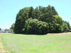
From the entrance of Kitakata-Kaido road to Kitakata city 3.8 km. It shows an overwhelming
presence in the northwestern paddy field, in the Aozu district of Hirose village. Both tumulus
together are designated as National Historic sites. Kame-ga-mori Kofun tumulus (picture up on
the left) is on the flatland, facing west with a Large keyhole-shaped
mound of 127m in length.
The rear circular part is 67m in diameter, 8m in height, the fron portion is 61m in length, 6m in
height, and can also check the traces of the horseshoe of the moat around
a tumulus. After to the
Raijin-yama Kofun tumulus (National Historic site) in Natori city, Miyagi
prefecture, the scale is
second largest in the Tohoku region (the first place in the mound in a flatland area). In the trial
excavation survey of Heisei 4 year (1992 year), fragments of Haniwa(clay
images) in the early
Kofun period were excavated, and confirmed the three-stage formation and
the roofing stone of
Push the page bottan
Kame-ga-mori & Chinju-mori Kofun
Mt. Takadera
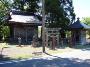
It is a shrine that enshrined along the road of the Kaeruda district 1.5
km from the Kawanishi
-Kaido road of the Usugamori-kofun east from Route 49 of the Niidate district. It is unknown
year it was the founded. Feast day is April 23. Enshrined is Sukunahiko-no -mikoto.
It is the god of the hot springs, to presides over the medical treatment
and the incantation.
In the origin of this shrine, the heart-friendly
episode of the ancestors of this district is conveyed.
After the "Former 9 years war" of 1051 ~ 1062 year, princess
Osawa the daughter of Abe-no-Sada to
was lived in seclusion to the Dosuga-sawa of the Todera village. The villagers were venerable and
correctly, the lifetime of a beautiful princess is merciful, it was comforting
to look after a few things,
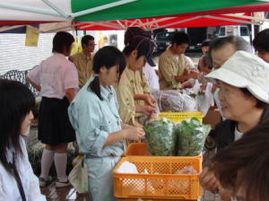
The production of vegetables, flowers, eggs and etc. that the students
of the prefectural Aizu
Agriculture and Forestry High School raised on, they regularly sell processed products such as
handmade cookies and breads every month. Opened in Heisei 16 year(2004
year). The quality,
safety and security are great reputation, and the product will be sold
out within an hour.
After school until the day before opening, it seems that the activity of the harvest of vegetable
to sell, the cookie and bread making (with tasting too?) every day busy until to late.
The proceeds are devoted to the seed and material costs for the next time.
With the theme of
contact with local people, the pleasure of making, it is the high school students who collaborate
with everyone of the shopkeepers group "Bange merchant Juku(school)"
in the town while
experiencing the difficulty and enjoyment of selling as a product.
Old Echigo-Kaido road in Aizu-Bange town
Old Echigo-Kaido road Oiwake stone
The old Echigo-Kaido road in Aizu-Bange town was introduced at the Usugamori-kofun
(Atago
shrine), but I looked for the remnants of the other old Kaido.From Shibata
in Echigo country
(Shibata city, Niigata prefecture) sailed up the Agano river and Aga river, and Ezo (Hokkaido)
and West-countries (more west of Kansai) supplies are, it was unloading
cargo in "Aozu" which
was the gateway of the west of Aizu at that time. From the Kofun period
to Keicho years of the
Tokugawa shogunate for about 1300 years, "Aozu" was the central of the current Kawanuma
county region. Shobusawa-toge pass – Aozu – Aoki – Tachikawa the route was the main road of
Echigo-Kaido road, and "Bange" was only in the one poor village
on a byroad. Because the
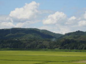
West of Aizu-Bange town, the foothills of the altitude of about 400m spread behind the Kami
-Unai settlement (photo , innermost, under the arrow).
It is said this mountain is has been recorded in Shinpen-Aizu-Fudoki and
Aizu-Kuji-Zakko etc,
and at Emperor Kinmei 1st year(540 year) the priest Seigan of Chinese
Ryo country(Liang, one
country of old China), entering Aizu and build the thatched hut lived
in Takadera mountain
and it was called Takadera-zan Musan-ji temple. In addition, at that time Buddhism had not
yet propagated the East Japan, but since then prosperity and sub temples
well reach over 3000.
Hoki 6 year(775 year), to abolished by military fire. It is said that,
the traditional place that the
first missionary to Japan from by Chinese Buddhism was direct transmitted.
There is no full-
fledged academic research or excavation of Takadera mountain, but if it
is physically proven,
Mountain which
failed to become Koyasan
Old Igarashi
family house
Route 49 to the right of the Y-junction of "Todera bay-pass point" toward Yanaizu town and
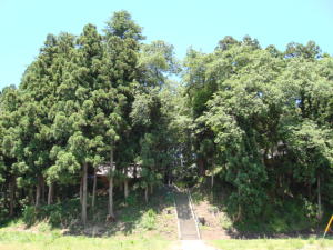
Niigata prefecture, go to the streets of the old Echigo-Kaido road Todera-juku(post-station-
town) when you climb the slope. This slope is also the old Route 49 and
the old Echigo-Kaido
road. Middle that, a small temple in front of Kokoro-Shimizu Hachiman
shrine is "Teacup Mou
nd Jizo". It is faith as a Koyasu Jizo(Child raising Jizo) in the
local. It is said that the approach
of Hachiman shrine passed straight from this around in Middle period.From under this temple,
it is called "Teacup Mound Jizo Kyozuka(Buddhist
scriptures mound)" because the sutra stone
of the word with a stone the Bonji(Chinese translation of the Sanskrit language of ancient India)
was written is excavated. This is an old tale of Teacup Mound Jizo(Chawan-zuka-Jizo).
Teacup Mound Jizo (Koyasu-Jizo, Jizo of children’s raising)
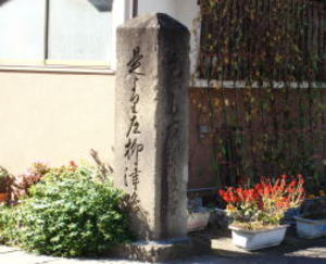
Ketanomiya settlements about 1km to the west of the old Echigo-Kaido road
Todera-juku (post-
station-town). A stone signpost about 2m in height that stands at the
entrance of "Kanetsuki-do
(bell tower)-toge pass ".Kanetsuki-do-toge pass is, told that it
was named because there was a
Bell-Tower in the mountain in this vicinity when the Takadera was prosperous. There is no
image of Shukuba-machi(post-station-town) in the houses of Ketanomiya
district and Todera
district, but it is the old legacy of reminded old Kaido road. This is
the branch point to Echigo-
Kaido road (toward Shibata city, Niigata prefecture) and Numata-Kaido
road(toward Nagaoka
city, Niigata prefecture), and is still now called Oiwake stone. You can clearlyread the good hand
writing of "this to the right Echigo-ji(road) and this to the left Yanaizu-ji(road)".
Osawa Shrine
Hero and heroine who bears the tomorrow of Aizu Bange is
popular in this town.
Kaino Fureai(contact) Mart(market)
Historical site of the 12th century fortified mansion as the
first-class in Japan.
3 km north of the Kawanishi-Kaido road from Route 49, further 0.7 km north
of "Kami-Unai
Yakushi", it is on a cliff raised by the activities of the "West margin fault zone of Aizu basin",
and overlooks the area of the western edge of the Aizu basin, it is construction in the land of
the strategic point. In the castle ruins that have been designated as a
National historic site,
the castle area is 50,000 square meters with double empty moat round in south, west, and
north, in the ruins of the 12th century are very few in Japan. In the Aizu-Korui-ki, Einin 2 year
(988 year, the time of directly ruled government of the Emperor Daigo
of the Heian period), the
Echigo-no-kami Jo Shiro Shigenori is a building of 8 fortified mansions in Kawanuma-county,
(partially omitted), South-Unai fort, and it is called named Jingamine-jo
castle.
Kamiunai Yakushi-Do
The
Chinju-mori Kofun tumulus (picture lower left) is also, facing west with Zenpo-Koho-fun
(square front, square back) on the flatland too. Length 55m, square front part 28m long, height
2.5m. The square back part is 31m south-north, 27m east-west and 5m in height scale, allowing
to see traces of mounds and moat around a tumulus.
A small shrine of Hachiman shrine is enshrined in the square back part.
It is estimated that the
construction in the middle of the 4th century from the excavated double-mouth-pot.
Do not full-fledged
excavation and research has been conducted.
the rear circular part, the tomb is estimated to be construction in the
second half of the 4th century. The square front part is a
cemetery of the district, and the rear circular part is considerably cut
because it was used as a mansion in the Middle centurys.
Currently "Aoki Inari Shrine" and, "Japan Heritage Aizu
33 Kannon", "No. 32 temple pilgrimage site Aozu Kannon (Sho-Kannon),
management of the Soto-shu(sect) Josen-ji temple" is enshrined. Although
no full-fledged excavation and research has been
conducted, it is a typical archaeological site that symbolizes the Kofun period in Aizu.
My paternal home is just near around the Kofun tumulus.


